
Our results for the second half of 2024:
In accordance with subtasks of calendar plan 1.2 (WP1.2) and 1.3 (WP1.3), the following work was completed:
1 A software and hardware platform for an unmanned aerial vehicle complex for performing monitoring tasks within the city economy (PABLKG) has been developed.
1.2 Prototypes of the PAPBLKG (heavier-than-air) hardware have been developed (WP1.2)
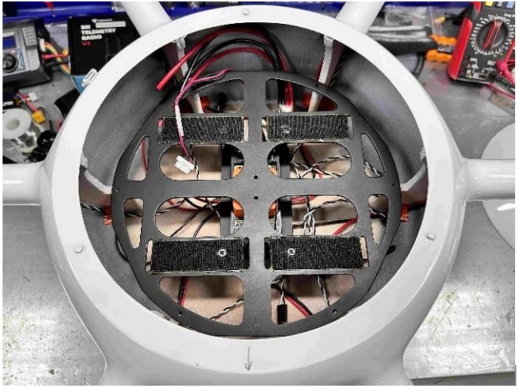
Composite drone parts manufactured. Components selected. Motor and battery controllers selected. Drone assembled and payload installed.
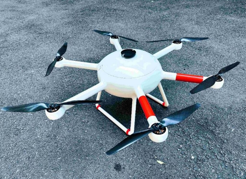
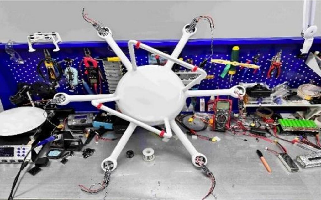
1.2.1 A universal drone for eco-monitoring based on a hexacopter has been developed and assembled.
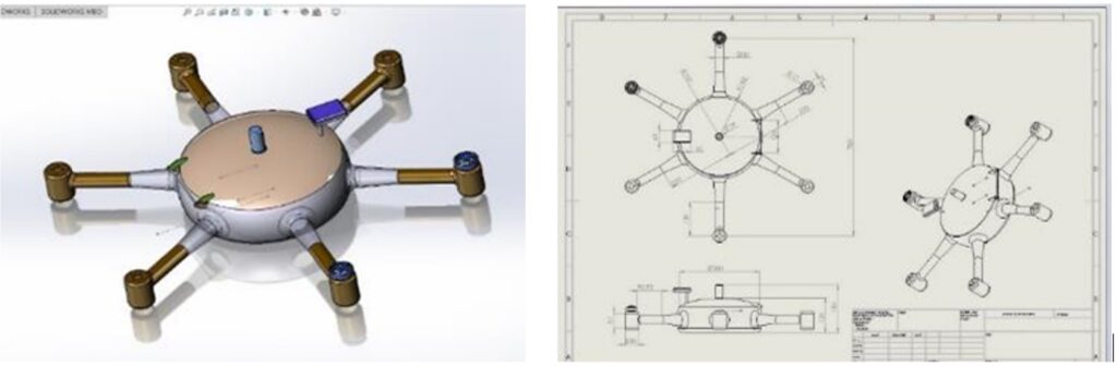
The drone frame was designed using the SolidWorks software product.
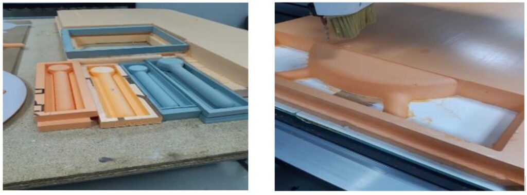
A drone with six engines (hexacopter) was selected based on the requirements of payload capacity, flight time, compactness and the ability to continue a safe flight in emergency mode if one of the engines fails. The production of master models of the drone body parts was carried out on a CNC machine. The manufacturing process is shown in the figure.
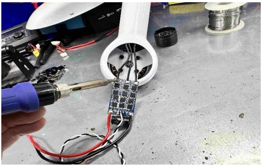
1.2.2 Components for the manufactured drone have been selected
An electric motor, propellers, controllers, speed controller, sensors, receiver, and batteries have been selected.
1.2.3 The drone is assembled with all components
1.3 Flight planning models and algorithms have been developed (WP1.3)
The following steps were performed: requirements analysis, optimization algorithms, creation of mathematical models, development of a program for converting the obtained waypoints, testing and validation.
2 A set of on-board mounted systems has been developed to solve the problems of monitoring urban infrastructure (detection of garbage, air and water pollution) (subtask WP2.2)
Atmospheric air analysis sensors have been developed that are installed on an unmanned aerial vehicle. The developed sensors are designed to measure pollutant indicators such as NO2, CO, NH3, CO2, VOCs, PM2.5, PM10.
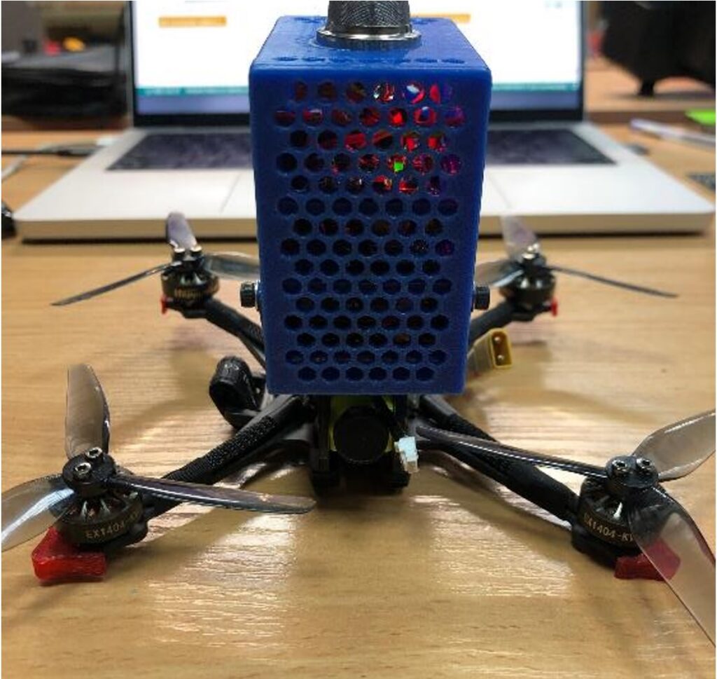
The 3D model of the sensors was designed using the Onshape CAD application. Models of all components were created at a scale of 1:1. The appearance of the housing is shown in the figure.

3 Software tools have been developed to solve problems of classification and recognition of images and data obtained from UAVs to solve problems of mapping environmental disturbances in the city’s air and ground environment, heat losses (subtasks WP3.1, WP3.2, WP3.3)
3.1 Overflights were conducted and data on pollution within the urban agglomeration was collected (WP3.1)
The flights were carried out by two drones: the first was equipped with a Micasense RedEdge-MX multispectral camera, an RGB camera and a FLIR thermal imager, the second drone was a DJI Mavic Mini equipped with an RGB camera.
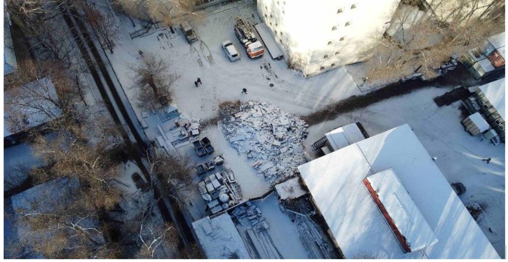
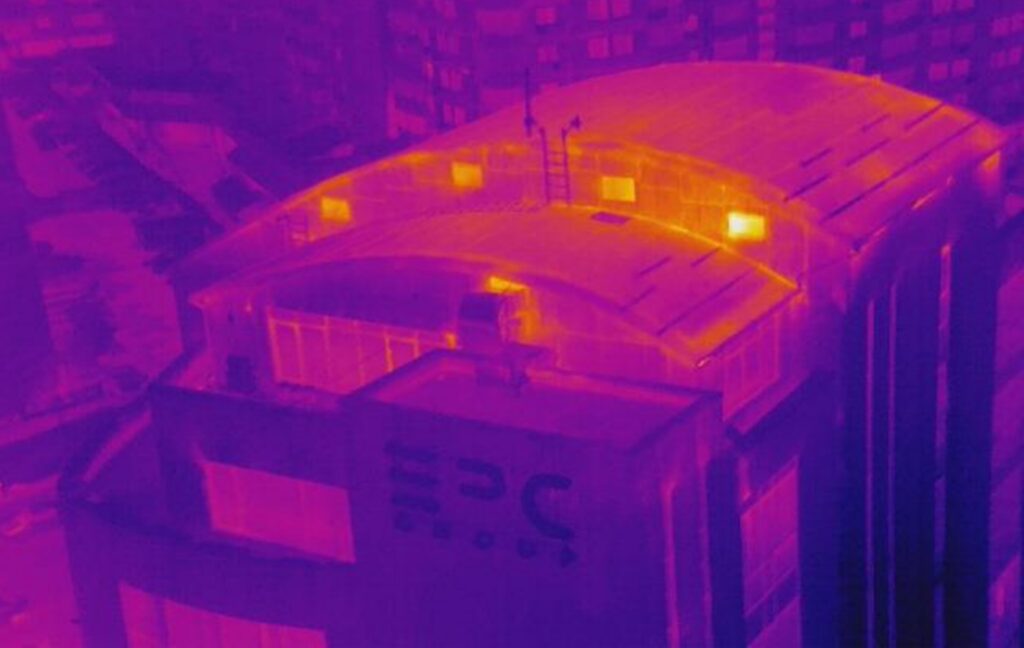
During the work carried out under the program, air quality measurements were taken using the AtmoTube Pro sensor.
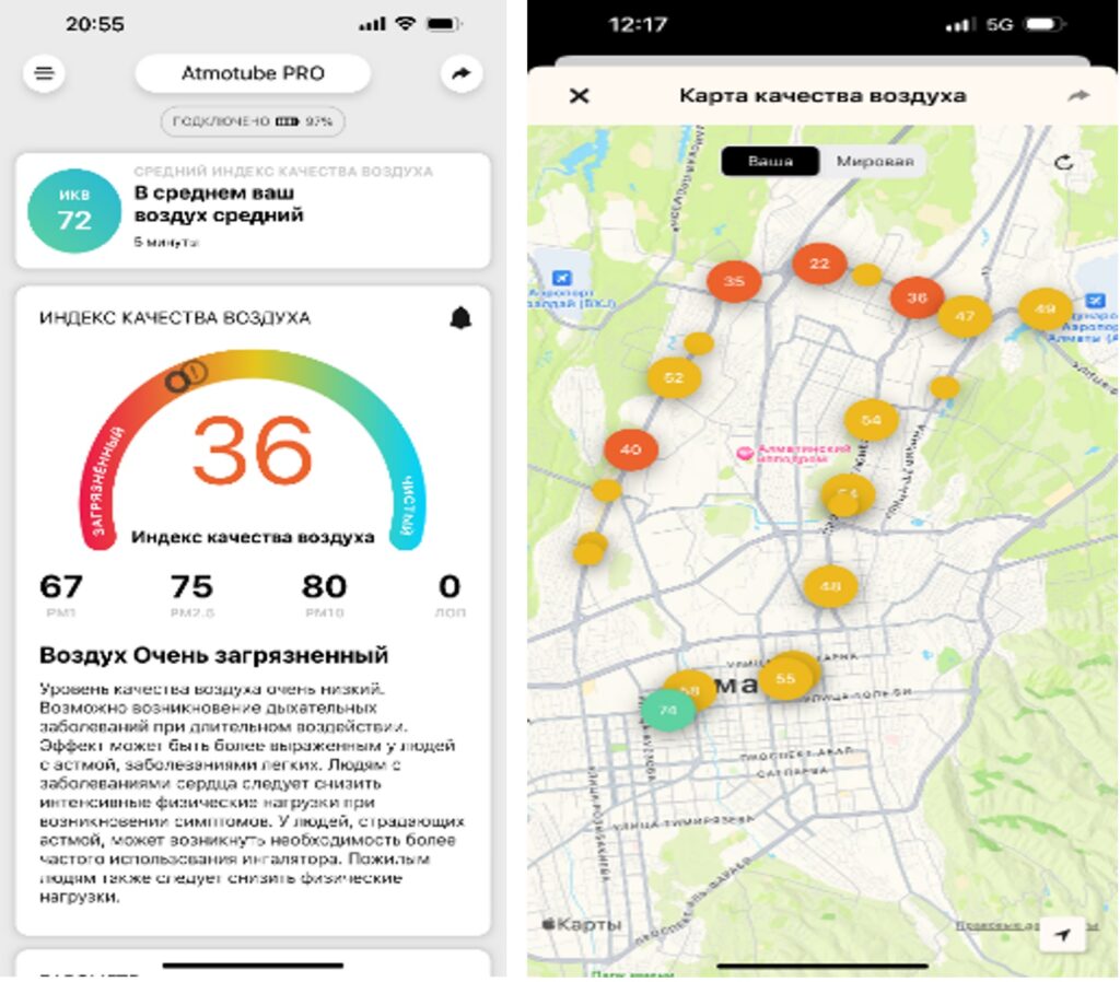
The AtmoTube Pro wearable sensor measures air quality (PM1, PM2.5, PM10), as well as volatile organic compounds (VOCs), temperature, humidity and atmospheric pressure.
During the measurements, the air quality is displayed in the sensor’s mobile application as an air quality index (AQI), calculated based on the above-mentioned PM and VOC indicators.
Next, an air quality map was built based on the measurements taken. Also, based on the air quality index, threshold values are displayed, summarizing the information and indicating the level of air pollution.
3.2 Labeled datasets of pollution within the urban agglomeration were generated for tuning machine learning models (WP3.2)
A comparison was made between the weather data services Weatherbit, OpenWeather, Yandex, stormglass and AQICN. Preference was given to OpenWeather and the Yandex.Weather service, since Stormglass and WeatherBit have a low update frequency and spatial resolution, as well as a limit on the number of free requests.
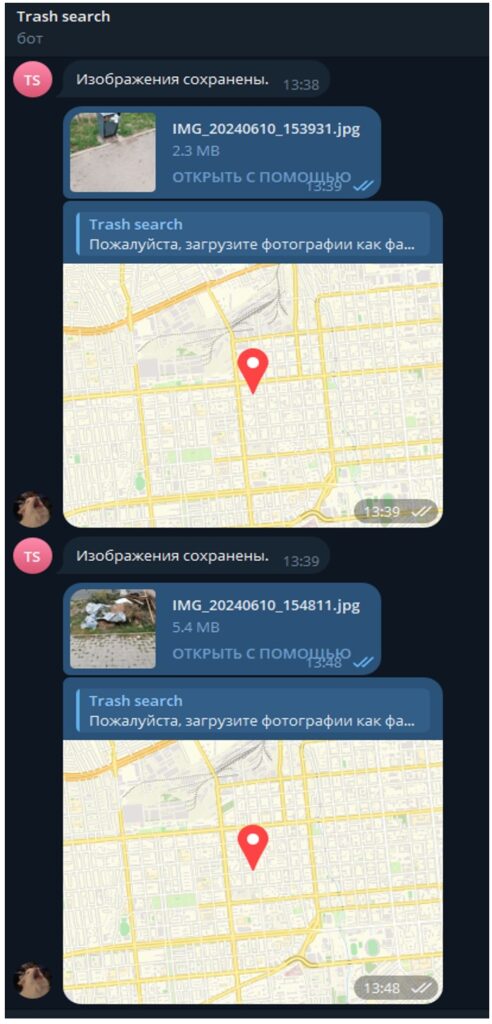
3.3. A Telegram bot has been developed to generate data sets about garbage using the crowdsourcing method.
3.3 Methods have been developed for solving problems of classification and recognition of images and data obtained from UAVs to solve problems of mapping environmental disturbances in the city’s air and ground environment, heat loss (WP3.3)
The possibilities of satellite monitoring of the spectral characteristics of the water surface of Lake Sorbulak (55 km2, wastewater storage facility for Almaty) in the Almaty region of Kazakhstan, which has been accumulating wastewater from Almaty since 1975, are considered.
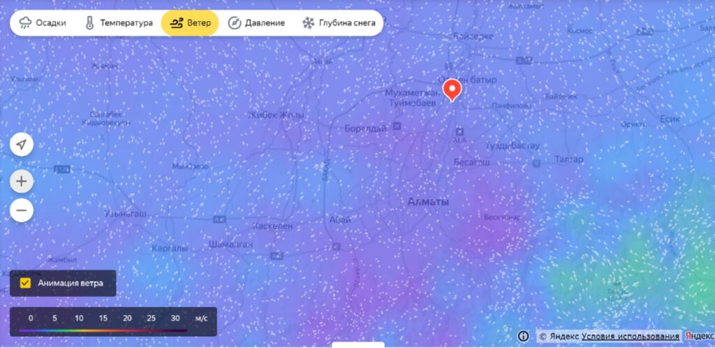
The activities of self-purification processes of the Almaty air basin due to mountain-valley circulation (MVC) in stable weather conditions were analyzed.
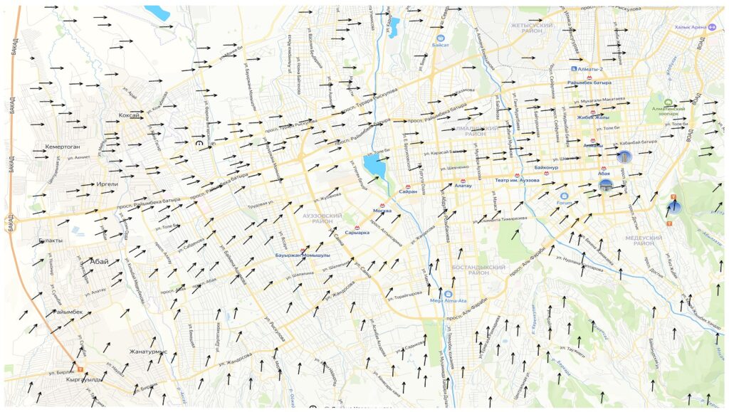
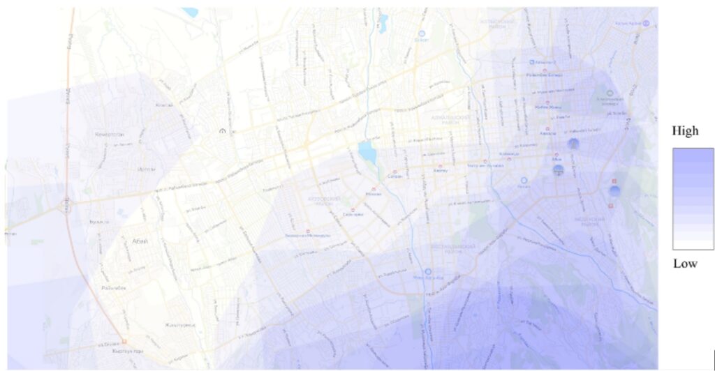
The activities of self-purification processes of the Almaty air basin due to mountain-valley circulation (MVC) under stable weather conditions were analyzed.
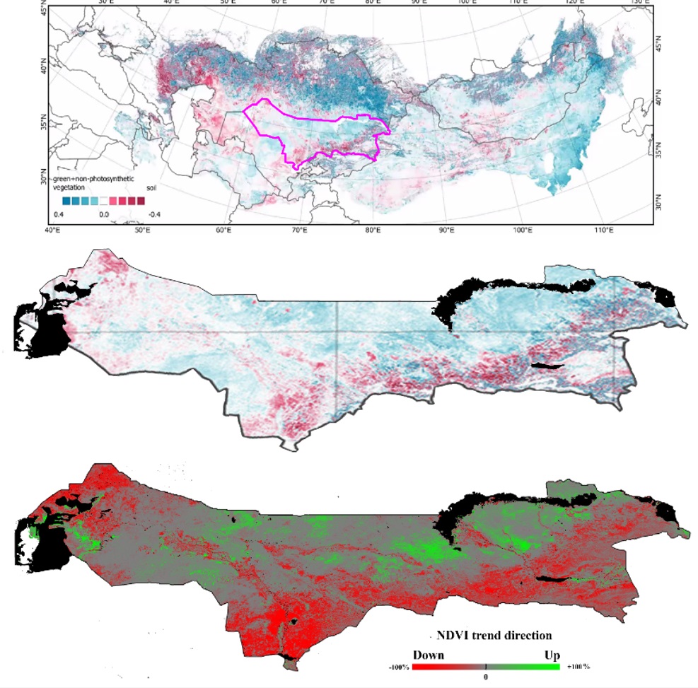
An analysis of the state of vegetation was carried out. Using Sentinel-2 data, available since 2016, with a spatial resolution of 10 m, made it possible to characterize the vegetation of urbanized areas, parks, squares, alleys and other plantings.
A comparison of the results of the trend analysis of the state of vegetation in southern Kazakhstan was built on the basis of a linear regression analysis of the time series of the MOD09A1 product (2002-2020) against estimates of the average direction of long-term monotonic trends (Mann-Kendall test) based on MOD13Q1A1_NDVI (2000-2022).
Change in atmospheric smoke in Almaty from January 27, 2025 to January 29, 2025 (result of a stationary camera)
List of published works on the topic for 2024
- Mukhamediev R.I. State-of-the-Art Results with the Fashion-MNIST Dataset // Mathematics. – 2024. – Т. 12. – P. 3174 https://doi.org/10.3390/math12203174. (CiteScore — Q1, 88%, JCR — Q1, IF: 2.3)
- Mukhamediev R.I., Terekhov A., Amirgaliyev Y., Popova Y., Malakhov D., Kuchin Y., Sagatdinova G., Symagulov A., Muhamedijeva E., Gricenko P. Using Pseudo-Color Maps and Machine Learning Methods to Estimate Long-Term Salinity of Soils // Agronomy. – 2024. – Т. 14. – P. 2103 https://doi.org/10.3390/agronomy14092103. (JCR – Q1, CiteScore – Q1, 84%, WoS IF=3.3)
- Mukhamediev R., Kuchin Y., Yunicheva N., Kalpeyeva Z., Muhamedijeva E., Gopejenko V., Rystygulov P. Classification of Logging Data Using Machine Learning Algorithms // Applied Sciences. – 2024. – Т. 14. – P. 7779 https://doi.org/10.3390/app14177779. (CiteScore — Q1, 79%, JCR — Q1, IF: 2.5)
- Mukhamediev R.I., Yelis M., Yakunin K., Popova Y., Kuchin Y., Symagulov A., Yunicheva N., Zaitseva E., Levashenko V., Muhamedijeva E., Gopejenko V., Mussabayev R. Exploring the health care system’s representation in the media through hierarchical topic modeling // Cogent Engineering. – 2024. – Т. 11. – P. 2324614. DOI: 10.1080/23311916.2024.2324614. (CiteScore — Q2, 64%, IF: 1.9)
- Тереxов А.Г., Сагатдинова Г.Н., Мухамедиев Р.И., Савин И.Ю., Амиргалиев Е.Н., Саиров С.Б. Перспективы использования псевдоцветных композитов при анализе многолетних временных рядов спутниковых данных в задаче оценки состояния растительного покрова // Современные проблемы дистанционного зондирования Земли из космоса. – 2023. – Т. 20. – № 6. – С. 51-66 https://doi.org/10.21046/2070-7401-2023-20-6-51-66.
- Оксененко А.А., Еримбетова А.С., Куанаев А., Мухамедиев Р.И., Кучин Я.И. Технические средства дистанционного мониторинга с помощью беспилотных летательных платформ // Известия НАН РК. – 2024. – Т. 3 (351). – С. 152-173 https://doi.org/10.32014/2024.2518-1726.298.
- Мухамедиев Р.И., Терехов А.Г., Оксенеко А.А., Еримбетова А.С., Кучин Я.И., Сымагулов А., Құсайын Д.Р., Рыстыгулов П. Эмуляция показаний датчиков качества воздуха в городской среде умного города // Гидрометеорология и экология. – 2024. – С. 87-99 https://doi.org/10.54668/2789-6323-2024-114-3-87-99.
- Смурыгин В.В., Құсайын Д.Р., Мухамедиев Р.И., Кучин Я.И., Исмаилов Д.В., Ксенофонтов Д.А. Парсер данных об уровне загрязненности воздушной среды городской агломерации// Научные труды ВИИРЭиС. – 2024. – № 4 (58). – С. 235-247.
- Свидетельство о внесении в государственный реестр прав на объекты, охраняемые авторским правом № 42480 от «30» января 2024 года Кучин Ян Игоревич, Мухамедиев Равиль Ильгизович, Терехов Алексей Геннадьевич, Сагатдинова Гульшат Наилевна, Сымагулов Адилхан, Кульдеев Нұрсұлтан Ержанұлы, Сағынұлы Санжар “Программный комплекс для оценки уровня воды в реке Или с использованием алгоритмов машинного обучения на основе оптических данных Sentinel-2” https://www.dropbox.com/scl/fi/dfqflosabeuhp9ojhmqhe/CUES.pdf?rlkey=1njy6jv9t7ffn9bki1f7kcfom&dl=0.
- Свидетельство о внесении в государственный реестр прав на объекты, охраняемые авторским правом № 43308 от «27» февраля 2024 года Құсайын Диас Русланұлы, Смурыгин Валентин Вадимович, Мухамедиев Равиль Ильгизович, Сымагулов Адилхан, Кучин Ян Игоревич, Еримбетова Айгерим Сембековна “Парсер данных об уровне загрязненности воздушной среды городской агломерации” https://www.dropbox.com/scl/fi/9et3ogkat1t6rwyj8ceo1/1.pdf?rlkey=j1qcz0f3ljeno4z4y94u6cfxr&dl=0.
- Свидетельство о внесении в государственный реестр прав на объекты, охраняемые авторским правом № 46522 от «28» мая 2024 года Смурыгин Валентин Вадимович, Мухамедиев Равиль Ильгизович, Сымагулов Адилхан “Программный комплекс для генерация карт сверхвысокого разрешения” https://www.dropbox.com/scl/fi/pdc021ljd2jhhdukoa556/.pdf?rlkey=23820nivwlw6lm3gtpwz2i8ik&st=jylh5anf&dl=0.
- Свидетельство о внесении в государственный реестр прав на объекты, охраняемые авторским правом № 47743 от «21» июня 2024 года Толеш Гульзина, Маншарипова Алмагуль Тулеуовна “Разработка пациент-ориентированной программы менеджмента реабилитации пациентов с хронической сердечной недостаточностью и сохраненной фракцией выброса для медико-социальных организаций и абиотических факторах”.
- Свидетельство о внесении в государственный реестр прав на объекты, охраняемые авторским правом № 46869 от «3» июня 2024 года Маншарипова Алмагуль Тулеуовна, Мухамедиев Равиль Ильгизович, Краснов Глеб Сергеевич, Тастайбек Тимур Аманжолович «Влияние экологческих факторов мегаполиса на организм пациентов с заболеваниями сердечно-сосудистой системы».
- Свидетельство о внесении в государственный реестр прав на объекты, охраняемые авторским правом №500695 от «1» октября 2024 года Маншарипова Алмагуль Тулеуовна, Кудабаева Венера Жанарбековна, Тастайбек Тимур Аманжолович «Качество жизни пожилых в программе активного долголетия и абиотические факторы».
Our results for the first half of 2024
In accordance with the tasks of the calendar plan, the following work was completed:
Section of the calendar plan: No. WP1.2. Development of prototypes of the hardware of the PAPBLKG (heavier-than-air devices).
Prototypes of hardware parts of the unmanned aerial complex have been developed. The main technical requirements have been considered, the design has been developed, the selection of components, assembly and configuration of the eco-monitoring drone with a flight weight of less than 250 grams have been presented. The main requirements for the drone related to the flight duration (battery life), flight and communication range, the ability to carry sensors and equipment, equipping with stabilization systems, equipping with GPS navigation, transmitting images from a camera, the ability of sensors on board the drone to detect gas and dust particles in the air to assess its quality, the presence of an automatic flight control system for the drone to perform specified routes and tasks without the constant participation of the operator have been taken into account. As well as taking into account the safety and reliability of the drone to ensure reliable operation in various conditions.
The main flight and technical requirements have been considered and taken into account. The selection of the layout and components is based on the following parameters: number of motors, motor arrangement, propeller diameter, removable arms or a solid plate, frame material, supported battery sizes, upper or lower battery mount. Selection of components: engine – HappyModel EX1404 3500KV, propeller – HQ Prop T3.5x2x3, AIO flight controller – HappyModel ELRS X1, video transmitter – RushFPV Tank Tiny, video camera – Caddx Ant 1200 TVL, video transmission antenna – RushFPV Cherry, radio control receiver antenna – Radiomaster T Antenna, GPS receiver – Flywoo GOKU GM10 Nano v3. Based on the selected components, a drone was assembled, the flight weight of which is 191 grams.
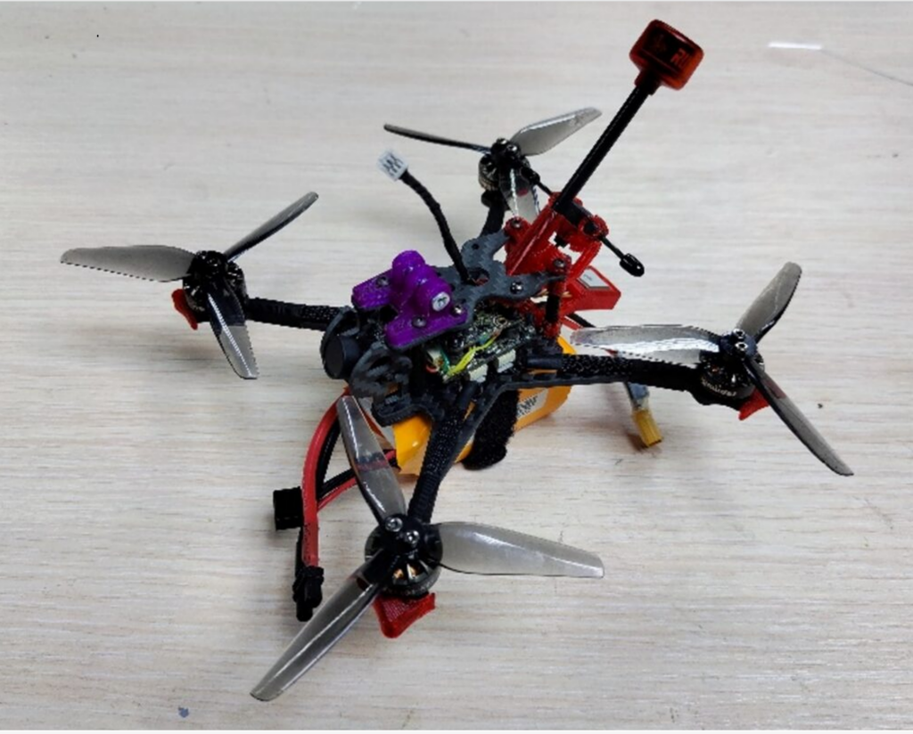
Setting up a Betaflight flight controller involves the general steps of connecting the controller to your computer, using the Betaflight Configurator configuration application, and performing several key settings: preparing the hardware, installing the drivers, installing the configurator, connecting to the configurator, calibrating, and setting up the radio control..
To configure the radio control equipment, the internal control transmission module was configured and the radio control channel sequence was configured. Test trials of the manufactured drone were conducted to analyze its correct operation and configuration before using it in real conditions. Testing the maximum flight time with a LiIon 3S battery was 24 minutes 26 seconds. Testing the maximum flight range was 8-10 km depending on weather conditions.
Based on the research results, a physical and mathematical article entitled “Technical means of remote monitoring using unmanned aerial platforms” was prepared and submitted for review to the journal Izvestiya of the National Academy of Sciences of the Republic of Kazakhstan, Series by Oksenenko A.A., Erimbetova A.S., Kuanayev A., Mukhamediyev R.I., Kuchin Ya.I.
The work will continue.
Section of the calendar plan: No. WP1.3 Development of flight planning models and algorithms.
Models and/or algorithms for planning flights of an unmanned aerial vehicle complex have been developed. Based on the developed algorithm for genetic optimization of routes for several UAVs within the Swarmown utility complex, it became possible to effectively identify and plan flights over objects of various types, such as groves, valleys, fields, agricultural and urban structures. In this regard, it became necessary to integrate these capabilities into existing software capable of accepting waypoints for building flight missions. As a result, QGroundControl was chosen as the most convenient option, taking into account the specifics of the existing equipment (Figure below). To ensure this integration, the PlanMaker utility was created, which generates waypoints in the .plan format required for QGroundControl.
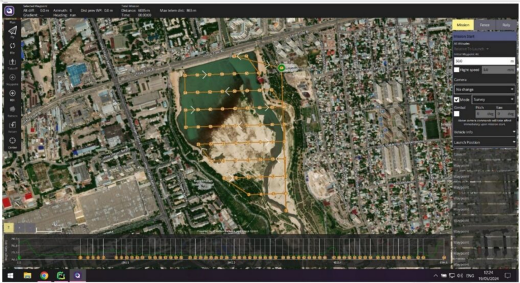
Based on this, practical experiments with UAVs and flight mission tests have begun. The genetic algorithm from the Swarmown utility suite determines a route close to the optimal one by means of multifactor stochastic optimization, which is then converted by the PlanMaker utility into a compatible format and imported into the QGroundControl platform. This allows planning the optimal route for several UAVs and then automatically controlling drone flights in real conditions. The work will be continued.
Section of the calendar plan No. WP2.2 “Development of BNS kits for solving environmental monitoring problems within the urban agglomeration”
Onboard mounted systems kits have been developed to solve environmental monitoring problems within the urban agglomeration. The main goal is to minimize the weight of the onboard kit to comply with legal restrictions on flights in the city. A prototype of the onboard mounted system has been assembled, which has the following sensors: gas sensor, accelerometer, gyroscope (MPU6050), and a microcontroller (ATmega328) as a control module. The microcontroller performs the following tasks: reading readings from sensors, pre-processing incoming data, applying noise filters, converting to the correct format, saving data. A power supply circuit from a lithium-polymer battery has been developed. The TP4056 circuit was used to provide battery charging from a 5V source, as well as protection against negative charge in the electrical circuit. The MT3608 circuit was used to output a stable 7V voltage from a dynamically changing voltage (3.2V – 4.2V) from the battery. The difference in the voltage of the transistor-transistor logic (TTL) buses of 5V and 3.3V between the microcontroller and MPU6050, including the gyroscope and accelerometer, was solved using the N-channel MOSFET BSS138. An algorithm for collecting and storing data on a TF flash drive was developed. The weight of the kit was optimized. The work will be continued.
Section of the calendar plan: No. WP3.1 Conducting overflights, collecting data on pollution within the urban agglomeration.
UAV overflights and ground measurements of air pollution were performed to collect pollution data in the urban agglomeration. The overflights were conducted using the partner’s equipment. The purpose of the overflights and ground measurements was not only to collect data, but also to practice the technical aspects of using the equipment. The overflights were conducted by two drones: the first was equipped with a Micasense RedEdge-MX multispectral camera, an RGB camera and a FLIR thermal imager, the second drone was a DJI Mavic Mini equipped with an RGB camera. A total of 8,320 photo images of the urban agglomeration were obtained, which display the state of the air, heat loss, and solid waste landfills. 550 measurements of air quality at different altitudes were taken with coordinates (PM1, PM2.5, PM10), as well as 1500 measurements of air quality (PM1, PM2.5, PM10), volatile organic compounds (VOC), temperature, humidity and atmospheric pressure using the AtmoTube Pro wearable sensor. Photos from the overflights are presented in figures below.
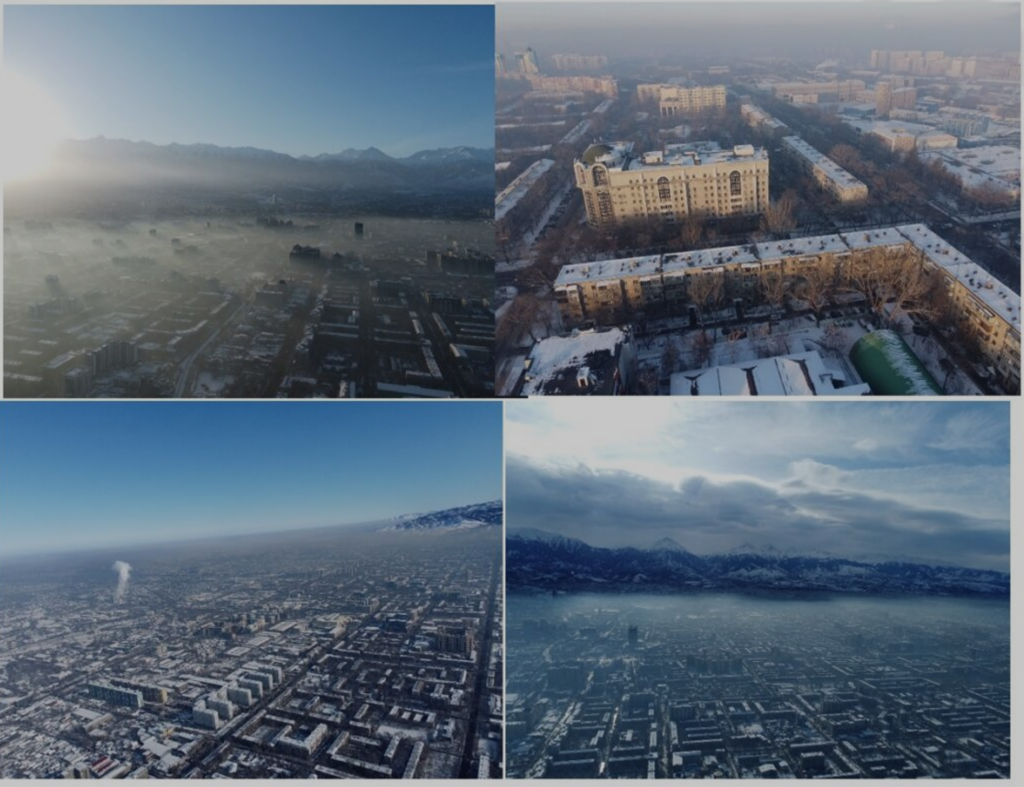
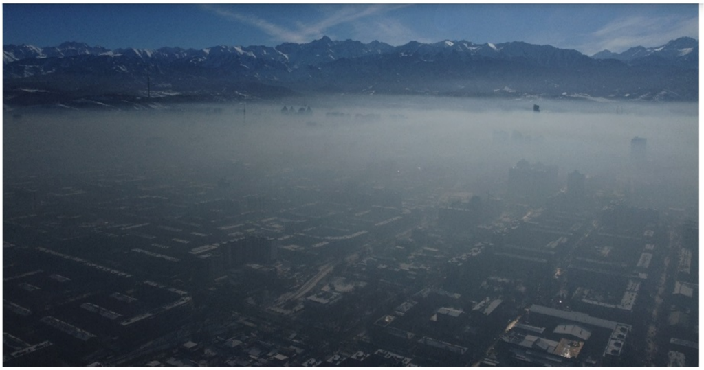
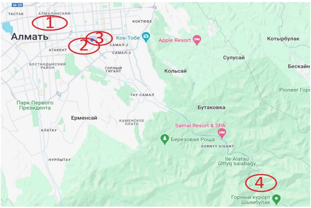
The flights were carried out on the territory of the Kazakh National Research Technical University named after K.I. Satpayev at the address: Almaty, Satpayev Street, 22, Medeu and Almaly districts of Almaty, as well as the area adjacent to the city. Flight protocols and data collected within the urban agglomeration have been prepared. The work will be continued.
Work Plan Section: #WP 3.2 Generating Labeled Pollution Datasets Within an Urban Agglomeration to Tune Machine Learning Models
A dataset was formed that includes air quality indicators and weather data collected several times a day at three points in Almaty from January to March 2024. The mentioned data collection points were numbered 0,1,6. (Figure below).
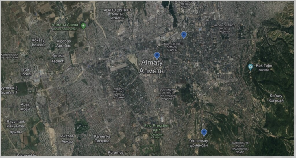
The distance between points 1 and 6 is 2.7 km, while the distance between 0 and 1 is about 7 km. The Atmotube Pro mobile air pollution sensor kit was used as a device for assessing air pollution..

Mobile air pollution sensor kit Atmotube Pro
The device measures the concentration of dust particles (PM1, PM2.5, PM10) and organic compounds (VOCs), as well as pressure, air humidity and temperature. The portal https://yandex.kz/pogoda was used as a source of weather data (wind direction and speed, humidity and temperature). Data at each measurement point was collected in tables. The data set of each sensor includes daily readings recorded at 9, 12, 15, 18 and 21 hours. PM1, PM2.5, PM10 – concentration of dust particles in μg per cubic meter with a size of 1, 2.5 and 10 μm, respectively. VOCs (volatile organic compound) – concentration of organic compounds, AQS (air quality score) – integrated air quality score, bar – air pressure. In addition, weather data (Yandex portal):
- wind_dir – wind direction in rhumbs (0 – north, 8 – south, 12 – west);
- wind_speed – wind speed in m/sec;
- temp – temperature at the measurement point;
- humidity – air humidity in percent.
In total, the original data set contains either 208 or 384 rows of data and 78 columns. The smaller number of rows corresponds to a time-synchronized file containing data from all three measurement points. This file can be obtained from the: linkhttps://www.dropbox.com/scl/fi/r25jfow8k3uuwlyqa0n8x/air_pollution_0_1_6.xlsx?rlkey=wej2da7x0be5wr3zu6e9q23dq&dl=0.
Depending on the purpose of the regression model, PM1, PM2.5, PM10, VOCs, and AQS were selected as the target parameter at one of the three sensors. The data of the target sensor were excluded from the data set. The weather data at the installation point of the target sensor remained in the data set. Depending on the purpose of the regression model, PM1, PM2.5, PM10, VOCs, and AQS were selected as the target parameter at one of the three sensors. The data of the target sensor were excluded from the data set. The weather data at the installation point of the target sensor remained in the data set. Based on the research results, an article by Mukhamediyev RI, Terekhov OG, Okseneko AA, Erembetova AS, Kuchin Ya.I., Symagulov A, Kusayyn Dias Ruslanuly “Emulation of air quality sensor readings in the urban environment of a smart city” was prepared and submitted for review to the journal “Hydrometeorology and Ecology”.
Based on the research results, an article by Mukhamediyev RI, Terekhov OG, Okseneko AA, Erembetova AS, Kuchin Ya.I., Symagulov A, Kusayyn Dias Ruslanuly “Emulation of air quality sensor readings in the urban environment of a smart city” was prepared and submitted for review to the journal “Hydrometeorology and Ecology”. The work will be continued.
Section of the calendar plan: No. WP 3.3 Development of methods for solving problems of classification and recognition of images and data obtained from UAVs to solve problems of mapping environmental disturbances in the city’s air and ground environment, and heat loss.
Methods and algorithms have been developed to solve problems of classification and recognition of images and data obtained from UAVs. Processing of Sentinel-2 satellite data (10 m resolution) to create spectral standards of key objects, with an assessment of their long-term (2016-2023) variability, for the purpose of calibrating UAV images and products based on them. Analysis and processing of Sentinel-2 satellite data (10 m resolution) was carried out, optimal algorithms for processing remote sensing data and spectral indices effective for assessing pollution of water bodies by components were determined: turbidity, chlorophyll content. Theoretical foundations for calibrating multi-scale data (ground – UAV – satellite) in Almaty conditions have been prepared to create spectral standards of key objects, with an assessment of their long-term (2016-2023) variability, for the purpose of calibrating UAV images and products based on them. A method for preparing images for classifying air pollution levels based on smog density on a 10-point scale for subsequent tuning of machine learning models is proposed. A crowdsourcing method for collecting pollution data based on the use of a telegram bot is proposed. Open resources on weather and air quality necessary for forming a large data set that can be used to predict pollution are considered and tested as a data source. The work will continue.
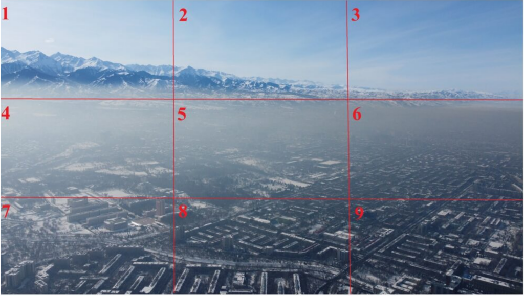
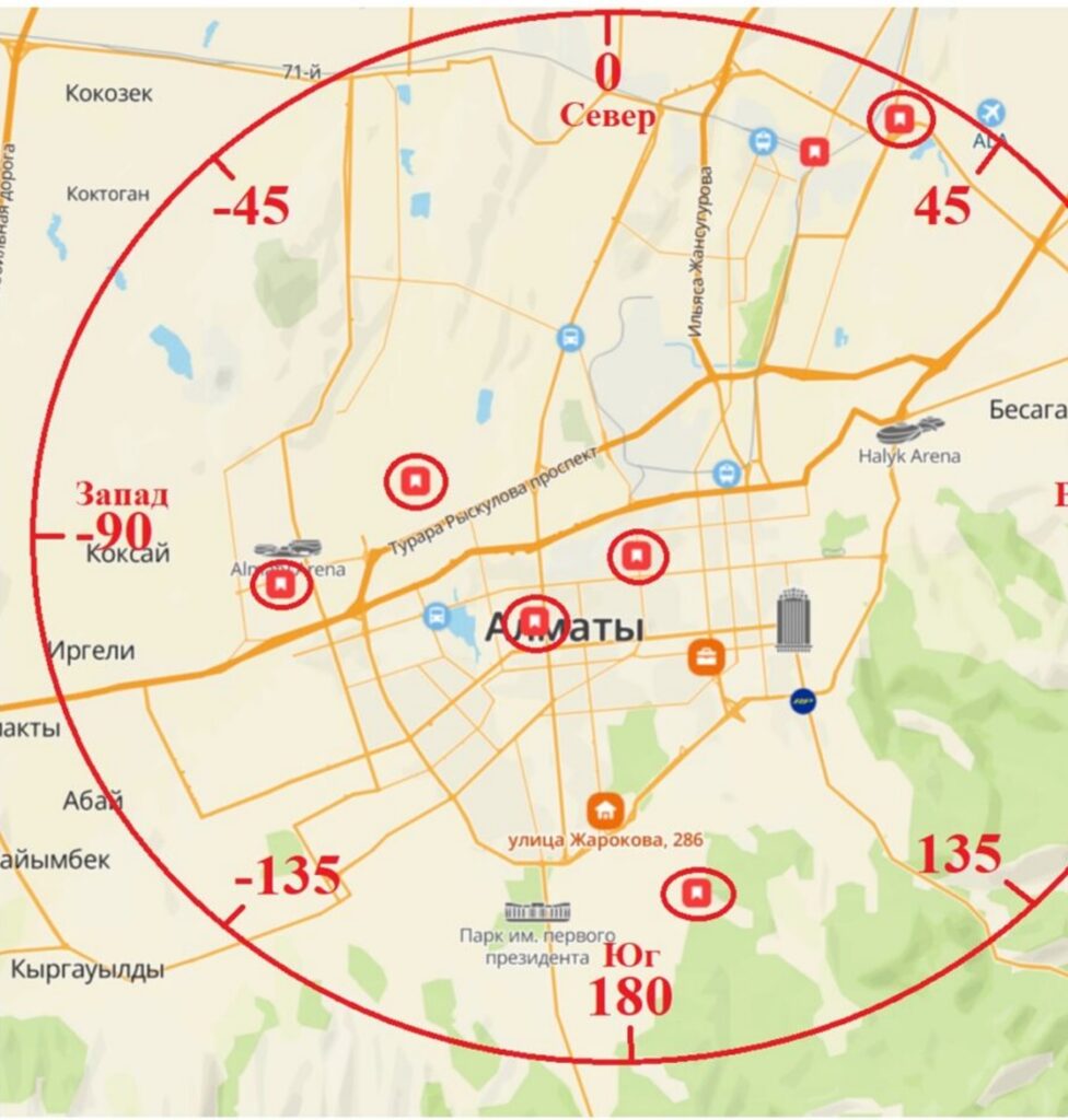
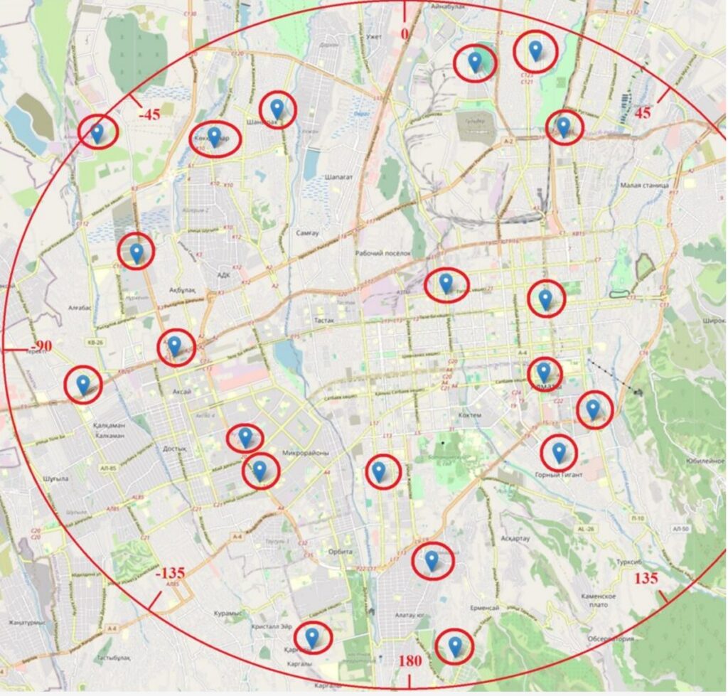
Section of the calendar plan: No. WP 4.1 Development of requirements for the system for displaying the received data and the results of their analysis.
A specification of requirements for the system for displaying the received data and the results of their analysis has been developed. The specification contains information on the functionality of the future development of the system, divided into the following modules: a module for storing data, visualization, cartographic layers and user tools. Measures have also been taken to implement a convenient mechanism for collecting data in the storage using a telegram bot, which significantly simplifies the process of accumulating and structuring information. The received data is subsequently displayed on the project website using the API, ensuring the availability and relevance of information for stakeholders (Figure below).
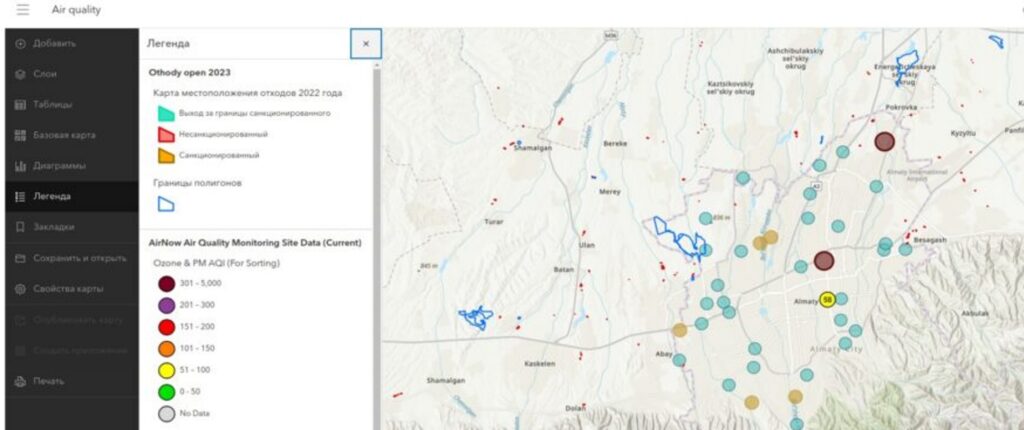
Open resources on weather and air quality have been tested within the framework of a prototype GIS data visualization system. The work will be continued.
Video of a soybean field taken from a drone:
List of published works:
- Ravil I. Mukhamediev, Marina Yelis, Kirill Yakunin, Yelena Popova, Yan Kuchin, Adilkhan Symagulov, Nadiya Yunicheva, Elena Zaitseva, Vitaly Levashenko, Elena Muhamedijeva, Viktors Gopejenko & Rustam Mussabayev (2024) Exploring the health care system’s representation in the media through hierarchical topic modeling, Cogent Engineering, 11:1, 2324614, DOI: 10.1080/23311916.2024.2324614 (Scopus Quartile: Q2, 64%, WoS IF=1.9).
- Zaitseva, E., Levashenko, V., Mukhamediev, R., Brinzei, N., Kovalenko, A., & Symagulov, A. (2023). Review of Reliability Assessment Methods of Drone Swarm (Fleet) and a New Importance Evaluation Based Method of Drone Swarm Structure Analysis. Mathematics, 11(11), 2551. https://www.mdpi.com/2227-7390/11/11/2551
- Mukhamediev, R.; Amirgaliyev, Y.; Kuchin, Y.; Aubakirov, M.; Terekhov, A.; Merembayev, T.; Yelis, M.; Zaitceva, E.; Levashenko, V.; Popova, Y.; Symagulov, A.; Tabynbayeva, L. Operational Mapping of Salinization Areas in Agricultural Fields Using Machine Learning Models Based on Low-Altitude Multispectral Images. Drones 2023, 7, 357. https://doi.org/10.3390/drones7060357
- Zaitseva, E., Levashenko, V., Brinzei, N., Kovalenko, A., Yelis, M., Gopejenko, V., & Mukhamediev, R. Reliability Assessment of UAV Fleets //Emerging Networking in the Digital Transformation Age: Approaches, Protocols, Platforms, Best Practices, and Energy Efficiency. – Cham : Springer Nature Switzerland, 2023. – С. 335-357. https://link.springer.com/chapter/10.1007/978-3-031-24963-1_19
- Mukhamediev R. I. Yakunin, K., Aubakirov, M., Assanov, I., Kuchin, Y., Symagulov, A., Levashenko V., Zatceva E., Sokolov D., Amirgaliyev, Y. . Coverage path planning optimization of heterogeneous UAVs group for precision agriculture //IEEE Access. – 2023. – Т. 11. – №. 15. – С. 5789-5803, doi: 10.1109/ACCESS.2023.3235207, https://ieeexplore.ieee.org/stamp/stamp.jsp?tp=&arnumber=10011226
- Yakunin, K.; Mukhamediev, R.I.; Yelis, M.; Kuchin, Y.; Symagulov, A.; Levashenko, V.; Zaitseva, E.; Aubakirov, M.; Yunicheva, N.; Muhamedijeva, E.; Gopejenko, V.; Popova, Y. Analysis of the Correlation between Mass-Media Publication Activity and COVID-19 Epidemiological Situation in Early 2022 //Information. – 2022. – Т. 13. – №. – С. 434. https://doi.org/10.3390/info13090434
- Mukhamediev, R. I., Popova, Y., Kuchin, Y., Zaitseva, E., Kalimoldayev, A., Levashenko V., Symagulov, A., Abdoldina F., Gopejenko V., Yakunin K., Muhamedijeva E., Yelis, M. Review of Artificial Intelligence and Machine Learning Technologies: Classification, Restrictions, Opportunities and Challenges //Mathematics. – 2022. – Т. 10. – №. – С. 2552. https://doi.org/10.3390/math10152552
- Mukhamediev R. I., Kuchin, Y. et al. Estimation of Filtration Properties of Host Rocks in Sandstone-type Uranium Deposits Using Machine Learning Methods //IEEE Access. – 2022. – T.10. – C.18855-18872. DOI 10.1109/ACCESS.2022.3149625; https://ieeexplore.ieee.org/abstract/document/9706226
Author’s certificates:
- Свидетельство о внесении в государственный реестр прав на объекты, охраняемые авторским правом № 42480 от «30» января 2024 года. Кучин Ян Игоревич, Мухамедиев Равиль Ильгизович, Терехов Алексей Геннадьевич, Сагатдинова Гульшат Наилевна, Сымагулов Адилхан, Кульдеев Нұрсұлтан Ержанұлы, Сағынұлы Санжар “Программный комплекс для оценки уровня воды в реке Или с использованием алгоритмов машинного обучения на основе оптических данных Sentinel-2” https://www.dropbox.com/scl/fi/dfqflosabeuhp9ojhmqhe/CUES.pdf?rlkey=1njy6jv9t7ffn9bki1f7kcfom&dl=0
- Свидетельство о внесении в государственный реестр прав на объекты, охраняемые авторским правом № 43308 от «27» февраля 2024 года. Құсайын Диас Русланұлы, Смурыгин Валентин Вадимович, Мухамедиев Равиль Ильгизович, Сымагулов Адилхан, Кучин Ян Игоревич, Еримбетова Айгерим Сембековна “Парсер данных об уровне загрязненности воздушной среды городской агломерации”
https://www.dropbox.com/scl/fo/lzrp2hqocsd2li4esv97b/h?rlkey=c5fjqmqlpsz6y5pk3lro8vyry&dl=0
- Свидетельство о внесении в государственный реестр прав на объекты, охраняемые авторским правом № 46522 от «28» мая 2024 года Смурыгин Валентин Вадимович, Мухамедиев Равиль Ильгизович, Сымагулов Адилхан “Программный комплекс для генерация карт сверхвысокого разрешения” https://www.dropbox.com/scl/fi/pdc021ljd2jhhdukoa556/.pdf?rlkey=23820nivwlw6lm3gtpwz2i8ik&st=jylh5anf&dl=0